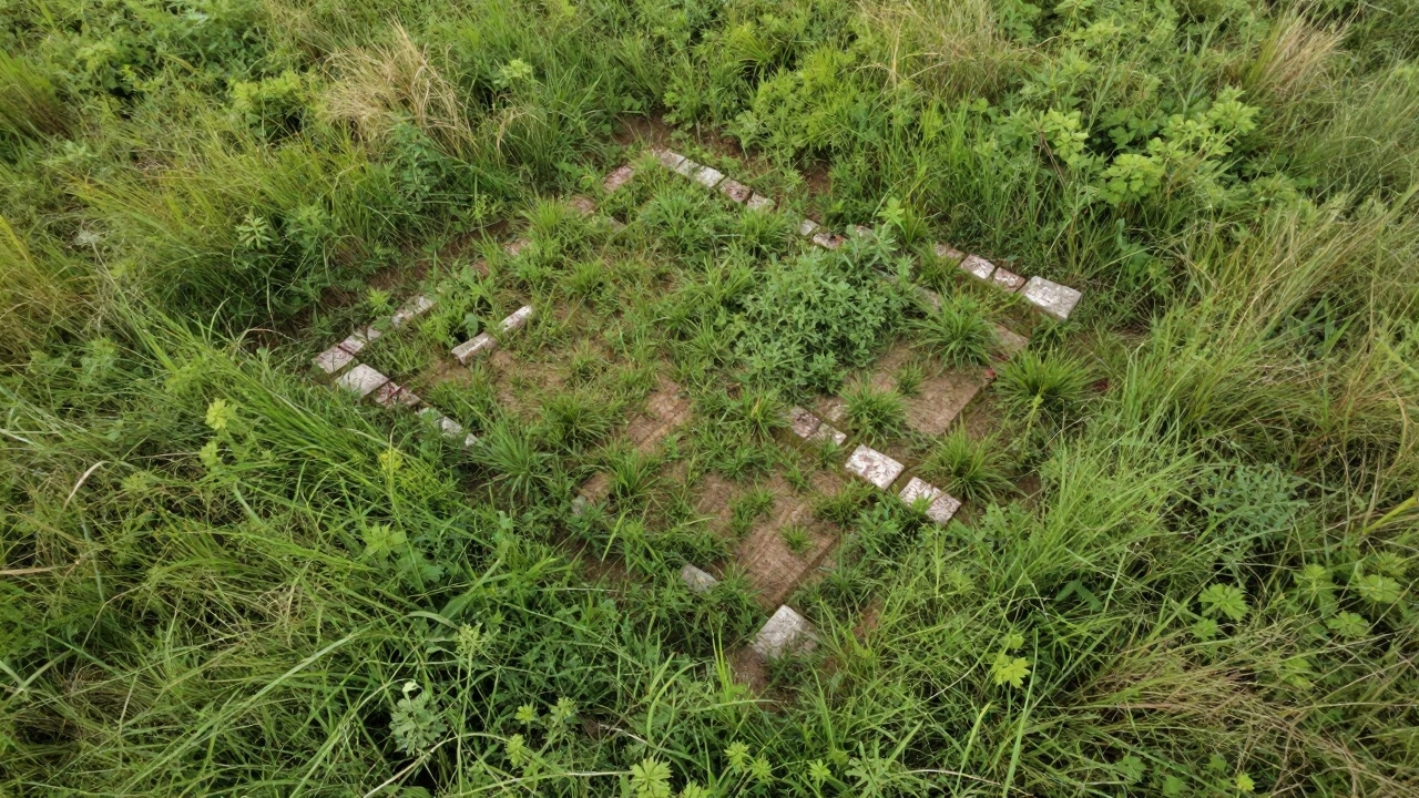
Imagine standing in a field that looks like nothing more than overgrown grass. To the naked eye, it’s just dirt and weeds. But from thirty feet up, you see it: the faint geometric outline of an ancient foundation, barely visible against the soil. This is the power of Kite Aerial Photography, or KAP. For archaeologists, this low-tech method has become a high-impact tool for mapping, documentation, and landscape surveys without the steep price tag of drones or helicopters.
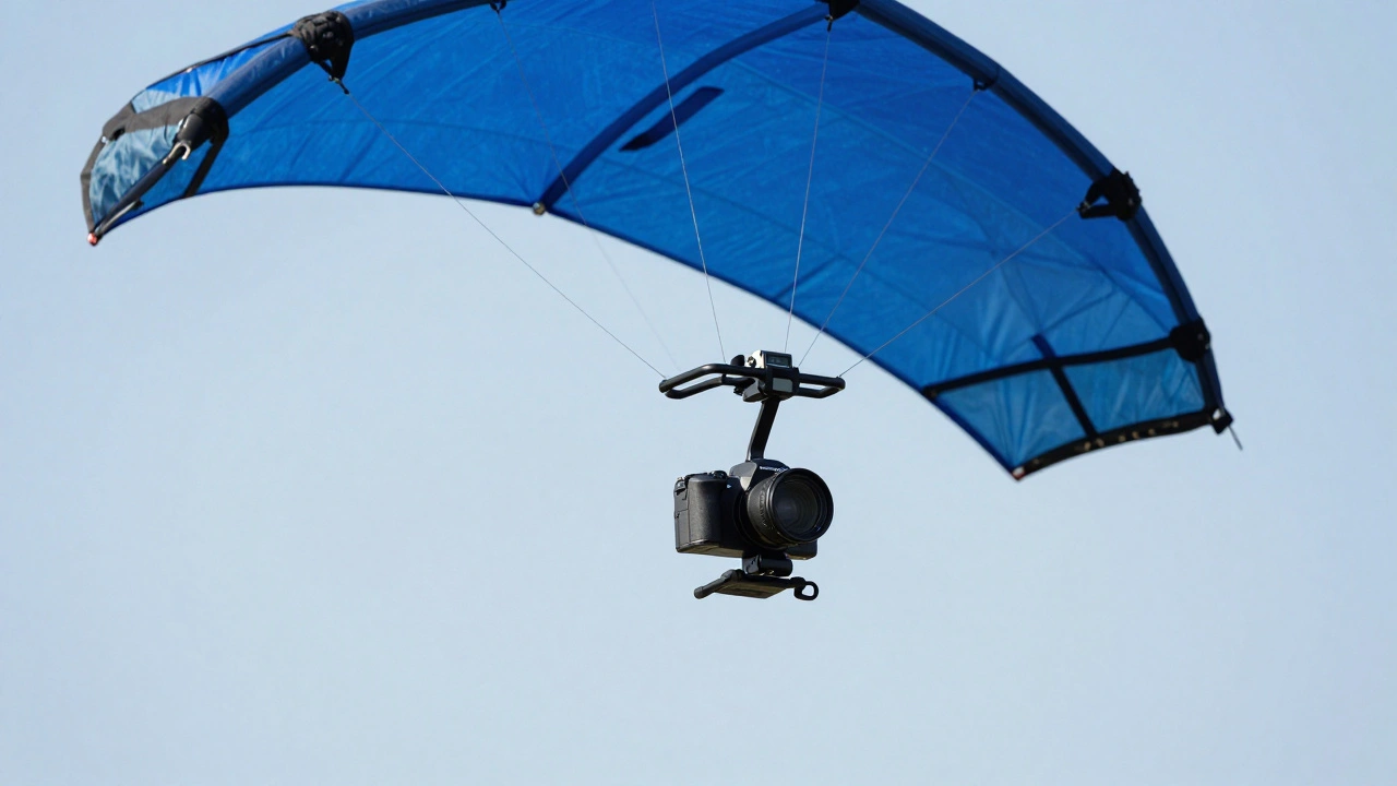
In recent years, drone technology has dominated aerial imaging. However, regulations are tightening, battery life remains limited, and costs continue to rise. KAP offers a compelling alternative. It uses a lightweight camera mounted on a line attached to a large sport kite. By controlling the kite’s position, you can capture high-resolution images from stable altitudes. The result? Detailed orthomosaics and 3D models of archaeological sites that rival commercial-grade data.
The Rise of KAP in Heritage Studies
Kite Aerial Photography is a technique using kites to lift cameras into the air for vertical or oblique photography. While hobbyists have used it for decades, its application in archaeological research exploded around 2015. Researchers needed affordable ways to document sites before they were lost to development or erosion. Traditional methods-like hand-drawn maps or ground-based total stations-are slow and often miss the bigger picture.
KAP fills that gap. It provides a bird’s-eye view that reveals patterns invisible from the ground. Think of crop marks, soil discolorations, or subtle earthworks. These features often only appear when viewed from above at specific angles and times of day. With KAP, you can capture these moments repeatedly, creating a visual record that spans seasons and years.
The beauty of KAP lies in its simplicity. You don’t need a pilot’s license. You don’t need to worry about no-fly zones near airports (though local laws still apply). And unlike drones, which can be noisy and intrusive, a kite is silent. This makes it ideal for sensitive sites where disturbance must be minimized.
Why Choose KAP Over Drones?
Let’s be honest: drones are convenient. They hover, they’re remote-controlled, and they come with apps that do half the work for you. But convenience comes with trade-offs. Here’s why many archaeologists are turning back to kites:
- Cost Efficiency: A basic KAP setup costs between $200 and $500. Entry-level drones start at $800 and quickly climb past $2,000 for professional models. Maintenance is cheaper too-no expensive motors or batteries to replace.
- Regulatory Freedom: In many countries, drones face strict rules regarding altitude, distance from people, and airspace restrictions. Kites generally fall under recreational use, making them easier to deploy in rural or restricted areas.
- Stability and Altitude: High-quality sport kites can hold steady positions at 50-100 feet. Some specialized kites go higher. This stability allows for longer exposure times and sharper images, especially in low-light conditions.
- Silent Operation: Drones buzz. Kites whisper. At heritage sites, silence matters. It reduces stress on wildlife and avoids disturbing nearby communities or ongoing excavations.
That said, KAP isn’t perfect. It requires wind-usually between 8 and 15 mph. Too little, and the kite won’t lift. Too much, and control becomes difficult. Wind also means unpredictability. You can’t schedule a shoot as precisely as you can with a drone. But for many projects, those limitations are worth the flexibility.
Setting Up Your KAP Rig for Archaeological Work
To get usable data, your equipment needs to be reliable and well-calibrated. Here’s what you’ll need:
- A Stable Sport Kite: Look for dual-line delta kites known for precision control. Brands like ParaWing or Ozone offer models designed for KAP. Avoid single-line kites-they lack maneuverability.
- A Lightweight Camera: Mirrorless cameras like the Sony Alpha series or Fujifilm X-series strike the right balance between weight and image quality. DSLRs work but add bulk. Action cameras (GoPro) are an option but sacrifice resolution and dynamic range.
- A Secure Mount: Use a custom-built harness or commercially available KAP mounts. Ensure the camera doesn’t tilt unless intentional. Vibration dampeners help reduce blur.
- Remote Trigger System: Wireless remotes or intervalometers let you take photos without touching the camera. Bluetooth triggers work if range permits.
- GPS Module: Attach a GPS logger to the camera or mount. This records location data for each photo, crucial for georeferencing later.
Before heading to the site, test your rig in open space. Practice launching, stabilizing, and retrieving. Check that the camera captures clear images during movement. Adjust settings for auto-focus and white balance based on lighting conditions.
Capturing Data: Techniques for Effective Surveys
Once you’re ready, the goal is to collect overlapping images that cover the entire area of interest. Follow these steps:
- Plan Your Flight Path: Divide the site into grid sections. Start at one corner and move systematically across the terrain. Aim for 70-80% overlap between consecutive shots. This ensures seamless stitching in post-processing.
- Maintain Consistent Altitude: Keep the kite at a fixed height relative to the ground. Variations cause distortion in final maps. Use visual landmarks or laser rangefinders to estimate distance.
- Shoot Vertically and Obliquely: Vertical shots provide top-down views for mapping. Oblique angles reveal depth and structure, useful for documenting walls, mounds, or terraces.
- Include Ground Control Points: Place marked targets (like colored squares) at known locations within the site. Measure their coordinates with a GPS device. These points anchor your images in real-world space.
- Monitor Weather Conditions: Wind gusts can shake the camera. If turbulence increases, pause shooting until conditions stabilize. Cloud cover affects lighting consistency-try to shoot under uniform skies.
After capturing enough frames, download the files immediately. Back them up on multiple drives. Corrupted memory cards ruin weeks of effort.
Processing Images into Maps and Models
Raw photos aren’t useful yet. You need software to stitch them together into georeferenced mosaics or 3D reconstructions. Popular tools include:
- Agisoft Metashape: Industry standard for photogrammetry. Handles large datasets efficiently. Produces accurate orthomosaics and dense point clouds.
- OpenDroneMap: Free, open-source alternative. Runs locally or via cloud services. Great for budget-conscious teams.
- QGIS: Open-source GIS platform. Import processed images here for further analysis, layering, and sharing.
The workflow typically involves:
- Importing all images into the software.
- Aligning them using automatic feature matching.
- Adding ground control points for scaling and positioning.
- Generating a dense point cloud-a collection of millions of XYZ coordinates.
- Creating a digital elevation model (DEM) or textured mesh.
- Exporting final products: orthophotos, contour lines, or interactive 3D viewers.
With proper calibration, accuracy reaches sub-centimeter levels. That’s precise enough to measure wall thicknesses or track erosion changes over time.
Real-World Applications in Archaeology
KAP isn’t just theory-it’s changing how we understand history. Consider these examples:
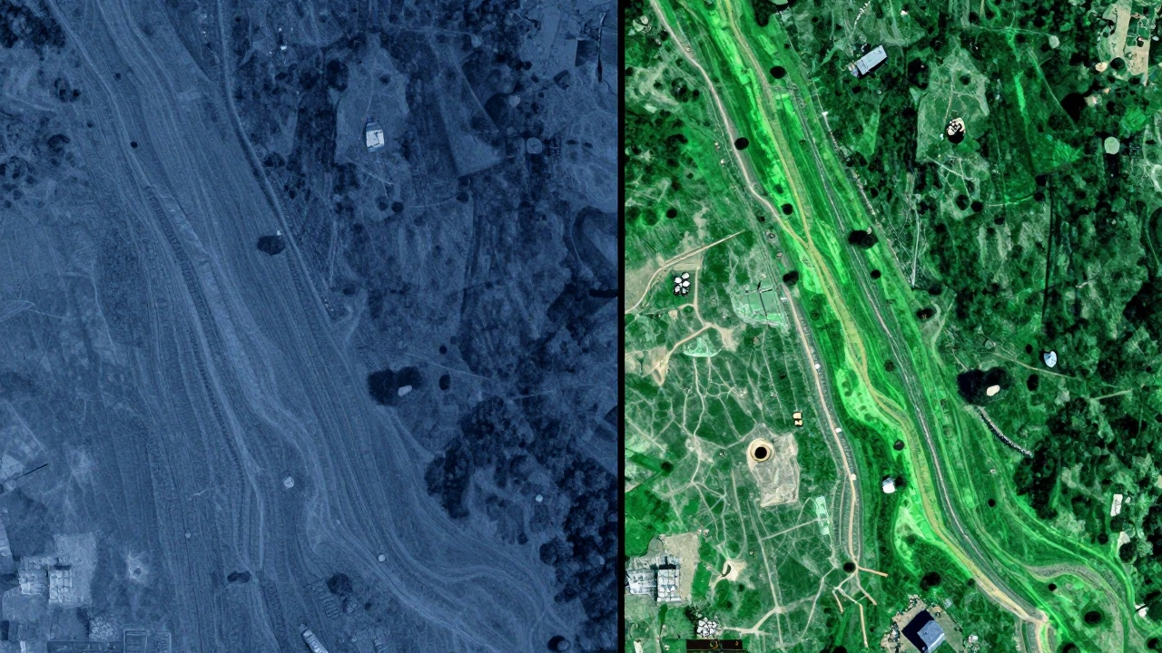
In Peru, researchers used KAP to map Inca road networks hidden beneath vegetation. From the ground, paths were indistinguishable. From above, linear anomalies stood out clearly. The resulting maps helped reconstruct trade routes and military movements.
In England, historic sites threatened by coastal erosion were documented annually using KAP. Comparing yearly images revealed gradual loss of structural integrity. Authorities used this data to prioritize preservation efforts.
In Turkey, KAP assisted in identifying previously unknown Bronze Age settlements. Subtle color variations in fields hinted at buried structures. Targeted digs confirmed findings, expanding our knowledge of regional urbanization.
These cases show KAP’s versatility. Whether documenting known monuments or discovering new ones, it delivers actionable insights quickly and affordably.
Challenges and Limitations
No tool is flawless. KAP faces several hurdles:
- Wind Dependency: Calm days mean no flights. Strong winds risk losing the kite or damaging gear.
- Limited Coverage Area: Compared to drones or aircraft, KAP covers smaller areas per session. Large sites require multiple visits.
- Learning Curve: Flying a kite while managing camera settings takes practice. Beginners may struggle initially.
- Data Processing Time: Stitching hundreds of images demands computing power. Slow laptops delay results.
Still, these challenges are manageable. Planning around weather forecasts helps. Modular setups allow expansion. Training improves skills. Affordable workstations handle processing tasks.
Future Directions for KAP in Archaeology
As technology evolves, so does KAP. Emerging trends include:
- AI-Assisted Image Analysis: Machine learning algorithms detect anomalies automatically, flagging potential features for review.
- Thermal Imaging Integration: Adding infrared sensors reveals subsurface structures through temperature differences.
- Multi-Kite Systems: Coordinated flights increase coverage speed and redundancy.
- Mobile Processing Apps: On-site rendering reduces turnaround time from days to hours.
These advancements promise even greater efficiency and insight. Yet core principles remain unchanged: affordability, accessibility, and effectiveness.
What is KAP in archaeology?
KAP stands for Kite Aerial Photography. In archaeology, it refers to using kites to lift cameras into the air for capturing high-resolution images of sites. These images are then processed into maps and 3D models for detailed study and documentation.
How does KAP compare to drone photography?
KAP is cheaper, quieter, and less regulated than drones. It relies on wind rather than batteries, offering longer flight durations. However, it lacks the precision and ease of operation provided by modern drones. Each has strengths depending on project needs.
Can KAP produce accurate archaeological maps?
Yes, with proper technique and processing, KAP can generate highly accurate maps. Using ground control points and photogrammetry software, resolutions reach sub-centimeter accuracy-suitable for measuring features and tracking changes over time.
Is KAP legal everywhere?
Generally yes, since kites are considered recreational items. Always check local regulations, especially near airports or protected lands. Some regions may impose restrictions on flying heights or permissions required for public spaces.
What kind of camera works best for KAP?
Lightweight mirrorless cameras offer the best balance of performance and portability. Models like Sony Alpha or Fujifilm X-series deliver excellent image quality without adding excessive weight. Ensure compatibility with wireless triggering systems.
Do I need special training to use KAP?
Basic kite-flying skills suffice initially. Advanced applications benefit from understanding photography basics, GPS usage, and photogrammetry workflows. Online tutorials and workshops enhance proficiency significantly.
How long does it take to process KAP images?
Processing time varies based on dataset size and hardware capabilities. Small projects complete within hours; larger ones span days. Efficient pipelines utilize powerful computers or cloud solutions to accelerate computation.
Can KAP help discover new archaeological sites?
Absolutely. Aerial perspectives reveal patterns missed from ground level-crop marks, soil stains, alignments. Many discoveries stem from such observations, guiding targeted investigations and confirming hypotheses.
Are there environmental concerns with KAP?
Minimal compared to motorized alternatives. Kites operate silently, avoiding noise pollution. No emissions occur during flight. Proper disposal of materials ensures sustainability throughout lifecycle.
Where can I learn more about implementing KAP?
Resources abound online-from instructional videos to academic papers. Join forums dedicated to KAP enthusiasts. Attend conferences focusing on heritage tech innovations. Hands-on experience accelerates mastery fastest.